About El Chaltén
A young town in Patagonia, at the foot of the unmistakable Mount Chaltén, or Fitz Roy. It is known around the world as Argentina's National Capital of Trekking, for the many trails and mountain routes that set out from its streets into a natural setting like no other.

Location
- Country
- Argentine Republic
- Province
- Santa Cruz
- Department
- Lago Argentino
- Latitude
- 49° 19′ 53″ South
- Longitude
- 72° 53′ 10″ West
- Average elevation
- 450 meters (1,476 ft) above sea level
El Chaltén lies in the west of Santa Cruz province, in the southern Andes, 215 km (134 mi) from El Calafate. It stands in a valley where the De las Vueltas and Fitz Roy rivers meet, next to Los Glaciares National Park, and is the gateway to the park's northern sector. Mount Chaltén, or Fitz Roy, dominates the landscape.

To plan your trip, How to get to El Chaltén covers flights, buses and roads, with maps and distances.

Origin of the name
The town owes its name to the legendary mountain that stands out among the surrounding peaks. Chaltén is a word from the Aonikenk language, used by the ancient Tehuelche to name this mountain, which they considered sacred. Its best-known meaning is "smoking mountain", because that is how it looks when the wind drags the clouds off its summit. Its story and its place in the Aonikenk worldview are told in the History of El Chaltén and in the Legend of Elal.
Geography and climate
The town sits in an ecotone, the transition zone between the steppe and the forest. The plains give way abruptly to a mountain range of wooded valleys crossed by rivers and streams.
The seasons are well defined. Summer is mild, with an average temperature of 12 °C (54 °F), long hours of daylight, frequent wind and moderate rain. Winter is cold, with an average of 2 °C (36 °F), short days, little wind and occasional snowfall. Forecasts, monthly temperatures and what to wear are in The weather in El Chaltén.

Wildlife
At this almost uninhabited latitude, wildlife finds in the valleys and mountains a paradise that remains largely untouched. Many species can only survive in these conditions. The best example of how fragile this environment is, protected by the National Park, is the huemul, an endemic deer in danger of extinction.
National Capital of Trekking
On January 12, 2015, National Law 27,055 declared El Chaltén the "National Capital of Trekking". It officially recognizes the extraordinary combination El Chaltén offers for mountain sports: a pristine, protected natural environment, many trails of varying difficulty, dozens of climbing routes of the highest technical difficulty and a town whose services grow around active tourism. Discover the self-guided treks and all the activities.

Tourist services
The range of services is very varied and keeps growing. There are plenty of places to stay: the most popular are hostels, cabins and apartments, and depending on what you are looking for you will also find campsites, mountain refuges, hotels and inns. The local food scene offers regional flavors and international cuisine in restaurants, pizza places, breweries and tea houses. It is all in the Services guide.
Founding
The town was created on October 12, 1985, as a geopolitical decision, at a time when Argentina was in a border dispute with Chile over the Lago del Desierto area and the Southern Patagonian Ice Field. Los Glaciares National Park ceded an area of 135 hectares to Santa Cruz province for the new town. The full story, from the Aonikenk to the 1994 ruling, is in the History of El Chaltén.
Growth
Today the population is around 3,000, and the figure changes year after year. Since its creation, El Chaltén has grown steadily, held back only by the limits of its land area. The 1991 census recorded 41 residents; by 2001 there were 371, by 2010 they reached 950 and in 2012 they passed one thousand. Urban development and tourism businesses keep expanding, which is why many public and private building projects are still under way.
Government
- Local government
- Autonomous municipality
- Provincial government
- Autonomous
- National government
- Republican, democratic, representative and federal
At first, the town was run by development commissions (comisiones de fomento) that answered to Río Gallegos, the provincial capital. They had limited resources and budgets, and their officials were not elected by the residents.
Once the town reached the required number of permanent residents, and with an urgent need for a government of its own, the provincial Constitution was partially amended in 2010 so that El Chaltén could become a municipality, which officially happened on November 24, 2011. In October 2015 residents voted for a mayor and town councilors for the first time, and they took office on December 12 of that year.
Coat of arms
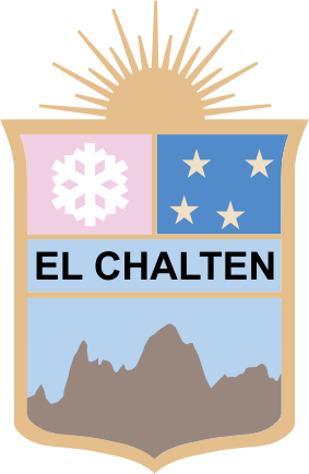
According to Article 5 of Law 1771, which created the town, the coat of arms "is made up of four quarters separated by gold borders that also surround the whole, with a rising sun, also in gold, as its crest. The upper left quarter shows, on a pink background (the color of the mountains that frame the town), an ice crystal, a symbol of the glaciers and eternal snows. The upper right quarter shows, on a blue background (representing the night sky), four golden stars symbolizing the Southern Cross. The central quarter bears the words 'EL CHALTÉN' on a light blue background, and the lower quarter shows, on a light blue background, the outline of the summit of El Chaltén".
Flag
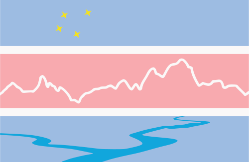
In the words of its designer, "the light blue and white stripes are shown just as in our National Flag. The pink stripe represents the color of the mountain ranges that frame the Town. The banner also includes the 'Southern Cross', tilted 30º from the horizontal, the emblem of the Aonikenk, who inhabited these southern lands; the 'Mountain Ranges of Cerro Torre and Mount Fitz Roy', representing Trekking and Climbing in the area; and the outline of the 'Confluence of the Fitz Roy and De las Vueltas Rivers', for its importance in the location of the Town".
Frequently asked questions
Updated: October 30, 2026
In the west of Santa Cruz province, in Argentine Patagonia, 215 km (134 mi) from El Calafate. It lies at the foot of Mount Fitz Roy, in the valley where the De las Vueltas and Fitz Roy rivers meet, and it is the gateway to the northern sector of Los Glaciares National Park.
It is the name the Aonikenk, or Tehuelche, gave to the mountain known today as Fitz Roy. Depending on the source, it means "smoking mountain", "bluish mountain" or "sacred mountain", because of the clouds that almost always surround its summit.
On October 12, 1985, under provincial Law 1771. It was a geopolitical decision, made at a time when Argentina and Chile disputed the border in the Lago del Desierto area.
Because National Law 27,055 declared it so in January 2015. The law recognizes a combination found in few places: a protected natural environment, trails of varying difficulty that start right from town, world-class climbing routes and a town whose services are built around active tourism.
The seasons are well defined. Summer is mild, with an average temperature of 12 °C (54 °F), long days, frequent wind and moderate rain. Winter is cold, with an average of 2 °C (36 °F), short days, less wind and occasional snowfall.
Learn more
- History
From the Aonikenk to the founding of the town - The Legend of Elal
The creator hero of the Aonikenk people - The National Park
Los Glaciares, World Heritage Site - Visitor Information Centres
Where to get trail, weather and town information - How to get there
Flights, buses and roads to El Chaltén - The weather
Temperatures, wind and what to wear